
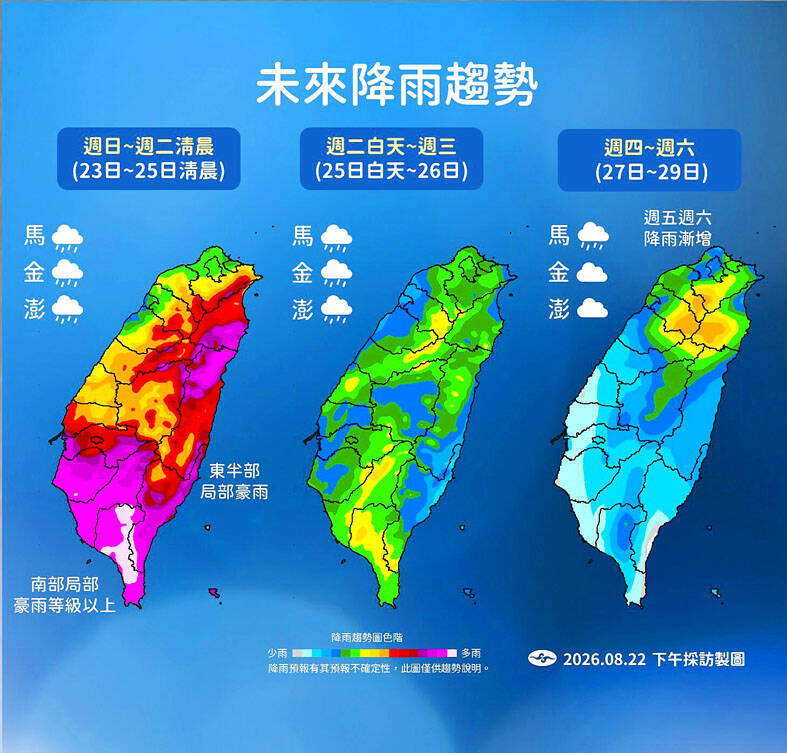
CYCLONIC SEASON: Heavy rains and strong winds are lashing southern and central Taiwan as a clutch of tropical storm events form around Taiwan and in the PacificBy Wu Liang-yi / Staff reporter, with CNA請繼續往下閱讀...The Central Weather Administration (CWA) yesterday forecast heavy rain for southern Taiwan today, saying tropical depression TD22 would strengthen southwesterly winds and bring more downpours.The CWA said that in addition to torrential rain in southern Taiwan yesterday, mountainous areas in central and southeastern Taiwan also saw heavy rainfall, while northern and northeastern mountain areas were hit by short-duration downpours amid intense afternoon thunderstorms.Tainan had experienced continuous rain since Friday night, with Yongkang District (永康) recording more than 132mm of rainfall in three hours and Rende District (仁德) nearly 100mm over the same period, the CWA said.By 3:20pm yesterday, Pingtung County’s Wandan Township (萬丹) had recorded 281mm of accumulated rainfall, the highest nationwide, followed by Majia Township (瑪家) with 263mm. Kaohsiung’s Siaogang District (小港) had recorded 254.5mm and Linyuan District (林園) 242mm, while Tainan’s Gueiren District (歸仁) had recorded 237.5mm.The CWA at 5pm yesterday activated enhanced operations for large-scale or severe rainfall as stronger southwesterly winds approached Taiwan. It said the most intense rainfall was expected from today through early Tuesday.Southern Taiwan could see extremely heavy rain during that period, while Chiayi and eastern Taiwan could see localized extremely heavy rain and central Taiwan localized heavy rain, it said.In its latest 24-hour rainfall forecast, covering 8pm yesterday to 8pm today, the CWA said mountainous areas of Chiayi County, Kaohsiung and Pingtung were expected to meet rainfall thresholds used in decisions on suspending work and classes.As of yesterday afternoon, TD22 was about 350km east of Taiwan. Although the Japan Meteorological Agency had upgraded the system to Typhoon Gaenari, the CWA continued to classify it as a tropical depression, saying its circulation and convection remained relatively weak.The CWA said TD22 was expected to move northwest before turning west toward the Chinese coast. Even if it strengthens into a typhoon, its forecast track would take it more than 300km north of Taiwan, making a sea warning unlikely, although the system is expected to strengthen the southwesterly flow and bring heavier rain to southern Taiwan.Typhoon Saudel was about 2,600km east of Taiwan at 2pm yesterday, with maximum sustained winds of about 137kph and gale-force winds extending an average of 180km from its center, the CWA said. It could strengthen into a strong typhoon today.Saudel is forecast to move northwest before turning west-northwest toward the Ryukyu Islands, reaching the area on Wednesday or Thursday. It is then expected to slow and could track farther west, bringing it somewhat closer to Taiwan, although its path remains uncertain, the CWA said.The typhoon’s outer clouds and circulation could bring increased rainfall to northern Taiwan on Friday and Saturday, with rain also possible in central and eastern Taiwan, it added.新聞來源:TAIPEI TIMES
评论 (0)